Background on Beulah
Beulah, on Appin Road south of Campbelltown, is a unique property that combines elements of both heritage and environmental significance.
The site contains a state-significant 1830s stone homestead and surrounding farm outbuildings alongside 60 hectares of critically endangered woodlands. Its history includes entrepreneurial Irish convicts and one of NSW’s most significant settlement families. The property was purchased by Sydney Living Museums (now Museums of History NSW) in 2010 and is being developed as an Endangered Houses Fund project.
... a comparatively rare example of colonial masonry construction...
Until recently, the Beulah homestead was generally assumed to have been built by one of the Hume family and the property has derived a great deal of its significance from this association. The Hume family were the pioneering settlers of the district and best known for the early explorations of Hamilton Hume and his overland journey of exploration to Port Phillip in 1824-25 with Captain William Hovell.
Research by Megan Martin, former head of Collections & Access at Sydney Living Museums, uncovered a different story which sheds new light on the story of Irish convicts in Australia.
The Beulah farmhouse was built around 1835-1836 by an emancipated Irish convict named Connor, or Cornelius, Boland, a native of County Clare, transported on the Three Bees in 1814. It was built on land promised to another emancipated Irish convict, Cornelius, or Connor, Bryan from County Tipperary, who had been transported for life on the Atlas 2 in 1802. Bryan was given an Absolute Pardon in 1812, promised the grant in 1814 and formally granted the land in 1823. By that time Bryan had long since returned to Ireland, leaving the property in the control of Connor Boland and a man called Thomas Connell, one of Bryan’s shipmates on the Atlas 2. Boland consolidated the property, buying two neighbouring grants sometime in the 1820s, although the title remained in the name of Denis O’Brien, one of Boland’s shipmates from the Three Bees and a fellow County Clare man.
Boland also acquired land in the Illawarra. He built up a substantial herd of cattle which he grazed at Appin and in the Illawarra and on a property near Maitland. He also bred horses. By the time he got his Absolute Pardon in 1834 he was already wealthy enough to return home. It is likely that he built the house largely as a means to maximizing the capital return on his assets. He put the property, then known as Summerhill, along with 250 head of cattle, on the market in September 1836 as he prepared to leave the colony. The advertisement for sale described the ‘lately erected’ cottage as:
a well finished substantial stone house, containing a verandah, passage, 8 good rooms and an attic story over the whole, fit for storage or any kind or servants’ apartments.
The Hume connection was established in 1846 when Francis Rawdon Hume bought Summerhill in the name of his six-year-old son, John Kennedy Hume. Francis already owned the front block of land that connected Summerhill to Appin Road and the adjacent property, Meadowvale. The front block was consolidated with the other Summerhill holdings to form the extent of the property as we now know it. Hume let Summerhill out to tenant farmers for the next 30 years.
In 1884 John Kennedy Hume, his wife Emma Johnson Clayton and ten-year-old daughter Ellen returned to Appin and changed the name of the property from Summerhill to Beulah, a Hebrew term for the land of Israel; the choice of this name may have been influenced by John Kennedy Hume’s adherence to the ideas of British Israelism. John, Emma and Ellen lived at Beulah for the rest of their lives, with John Kennedy Hume dying there in 1905 and his widow Emma in 1919. Ellen died unmarried in 1936 and the property began a long decline into dereliction.
Ellen Hume left the property to the Royal Society for the Prevention of Cruelty to Animals (RSPCA) but with the provision that her “maid and companion” Sarah Papworth and her husband could continue to have the “use and enjoyment” of Beulah for as long as she made the property her principal place of residence. Sarah died in 1960 and David continued living at Beulah until his own death in 1967.
Following David Papworth’s death the house chattels were distributed between various beneficiaries of Ellen Hume while other items disappeared or were given away by the RSPCA. The property was formally conveyed to the RSPCA in December 1969, they promptly auctioned the property the following year. The property was bought by Beulah Investments, a land investment company that was anticipating the expansion of metropolitan Sydney into the south-west sector. While they waited for the hoped-for rezoning of the land, the company let parts of the property out on agistment leases. The farm buildings continued to deteriorate but, following assessments by the State Planning Authority and the National Trust, Beulah was formally classified in 1980 on the National Trust register as a significant heritage item and in 1987 a Permanent Conservation Order was placed over the homestead and its surrounding farm building and fences.
In 2002 Beulah Investments were advised by the NSW Heritage Branch that they were in breach of the Heritage Act by allowing the deterioration of the homestead. The heritage architects Clive Lucas Stapleton and Partners were contracted to assess the building and in 2004 they supervised a schedule of repair works on the building including the reconstruction of the collapsed stone walls of the two northern verandah rooms, the reconstruction of a roof structure over these rooms, and the replacement of five verandah posts to match the originals
It was around this time that the Historic Houses Trust of New South Wales (HHT, now MHNSW) became aware of Beulah. In August 2004 the then Director of the HHT, Peter Watts, wrote to Beulah Investments explaining that the property had been brought to the Trust’s attention as a potential candidate for the Trust’s Endangered Houses Fund (EHF).
In September 2010, the HHT entered into a funding agreement with the Office of Environment & Heritage to purchase the property through the EHF. The Office of Environment and Heritage’s interest in Beulah was because of the significance of the 60 hectares of bushland on the property. This rare remnant parcel of woodland had been first noted in a study of the native vegetation of the Sydney area published in 1969 and had been further explored by botanist Doug Benson from Sydney’s Royal Botanic Gardens in a report completed in 1986.
The bush in the front block of Beulah may never have been cleared. The block is crossed by Woodhouse Creek, with the woodlands to the east of the creek comprising endangered Shale Transitional Forest while the woodlands to the west transition into critically endangered Cumberland Plains Woodland. The block of woodlands and the connecting ribbon of bush that extends along the northern boundary of Beulah provide a wildlife corridor between the Georges and Nepean rivers. The bushland also includes areas of high indigenous archaeological sensitivity, particularly around the creek bed and its four tributaries.
The Office of Environment & Heritage contributed funds towards the purchase of Beulah through the Growth Centres Biodiversity Offset Program. In return for their support, the HHT agreed to the 60 hectares of bushland being turned into a Biobank area. The Biobank status provides permanent conservation for the bushland and establishes a trust fund from which the owner of the land is paid an annual fee in perpetuity to manage and maintain the land. The annual funding pays for a prescribed program of bush management works that includes weeding, revegetation, fencing, controlled burns and pest control.
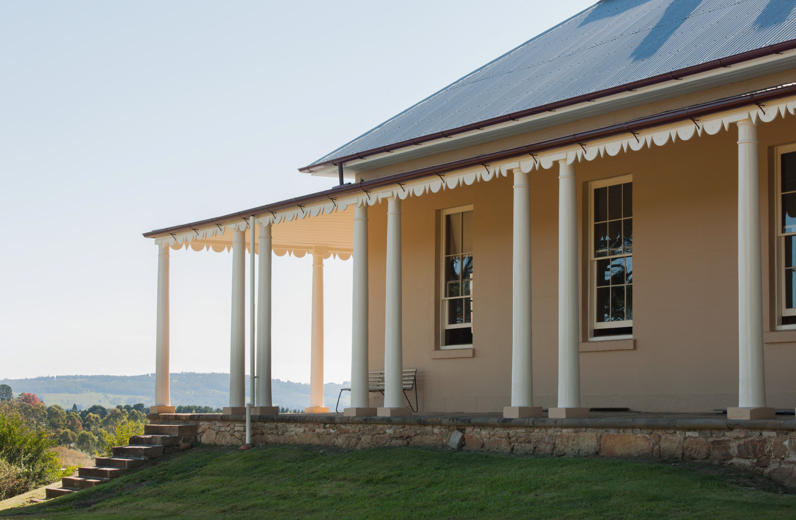
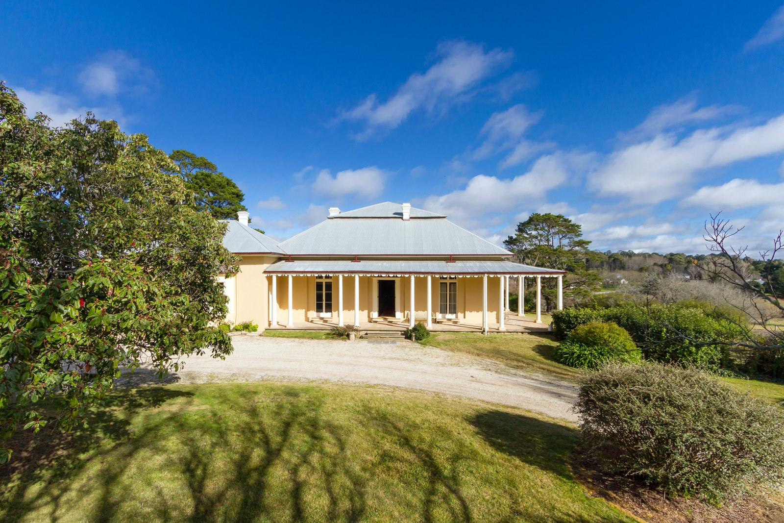
The significant heritage items on the property include the 1830s homestead, the footings of the homestead’s previous outbuildings and vestiges of its former formal gardens, the dilapidated timber farm buildings and summer house, remnant post and rail fencing, the round yard in front of the homestead, and the stone bridge on the driveway in from Appin Road. The property provides rare evidence of agricultural practices on a farming property that was continuously occupied and worked from the 1820s to the 1960s.
The homestead is a comparatively rare example of colonial masonry construction and retains its original plan and form as described in the 1836 advertisement for sale. Significant elements include the remnant shingle roof, rubble wall construction, flagged verandah and the overall form and arrangement. The views to and from the homestead are unchanged from the 1820s. The building is, however, in dilapidated condition, with sections of collapsed ceilings and floors, missing windows and doors and no internal fittings. Conservation of the house will be a significant project.
To the south of the house are two timber farm buildings – both in a severely ruined state. Closest to the homestead is the former farm-manager’s cottage, one section of which has completely collapsed. A further 50 metres away is the remnants of the coach-shed, again largely fallen. On the crest of the ridgeline that traverses the property, 100 metres to the west of the homestead, sits the remnant octagon-shaped roofed of the gazebo, where the occupants of the farm would have previously gone to enjoy the breezes and views across the Menangle Valley, Southern Highlands and adjacent Hume homestead (Meadowvale).
The bridge that spans Woodhouse Creek on the driveway in from Appin Road is a remarkable structure. The age of the bridge is debated; it may date from the period of construction of the homestead or, more likely, from shortly after the purchase of Summerhill by Francis Rawdon Hume. Either way, the structure is probably still the oldest surviving stone bridge on private property on the Australian mainland. The stone abutments of the bridge are intact although the original timber bearers and deck, and a secondary deck that was overlaid around the 1950s have since collapsed. Along with the roadway, the bridge forms a romantic bush-lined access way in to the homestead group and open pastures at the rear of the property.
As a first step in the conservation of the property the SLM Heritage Team is working towards the reinstatement of the Beulah driveway and bridge.
Published on
Richard Taylor
Former Project Manager
Richard Taylor was a project manager in the heritage team at Sydney Living Museums.
Related
Browse all![Tusculum, Macleay Street, Potts Point [residence of the Long family], ca. 1886-1888](https://images.mhnsw.au/fotoweb/embed/2025/04/5588565ef3134032bf5424c329d22a62.jpg)
Tusculum
Saved from demolition in the 1980s, Tusculum represents a highpoint in Regency architectural design in Australia
Locking up at Throsby Park
Among the set of house keys for Throsby Park are a number of very large brass mortice keys for 19th century internal door locks
Throsby Park: a comfortable residence
Discover the fascinating story of Throsby Park, a rural property near Moss Vale in the southern highlands, New South Wales, Australia, rescued, stabilised and conserved by Museums of History NSW
Throsby Park: a place of value
What does it really mean when we say Throsby Park is of state heritage significance?